
[ TSUNAMI PREPAREDNESS /
55TH ANNIVERSARY OF 1946 HILO WAVE ]
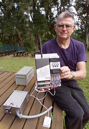
New technology A SIMPLE DEVICE invented by Hawaii seismologist Dan Walker with security industry and cell-phone technology could lead to faster warnings for locally generated tsunamis.
promises to improve
tsunami alert
Sensors could help scientists
differentiate between false
alarms and the real thing>> Gambling on tsunami
>> Tsunami ChecklistBy Helen Altonn
Star-Bulletin"You combine those two items and put them on land, maybe 10 feet above sea level, and you'll be able to detect when land is invaded by water," said Walker, retired University of Hawaii scientist, now tsunami advisor to the Oahu Civil Defense Agency.
If tests are successful, he said, a series of sensors will be placed along the Kona and Puna coasts in places where storm surf normally does not occur. Although storm waves can be high, tsunami waves travel further inland, Walker noted.
An instrument flooded by a tsunami would instantly trigger an alarm at the Pacific Tsunami Warning Center at Ewa Beach, he said.
Most earthquakes do not cause tsunamis, Walker said. "But imagine if you had two or three sites and all had vertical heights of 10 feet (waves) -- that's a pretty significant tsunami.
"We don't know how frequently those types of tsunamis occur -- maybe every 100 years or 300 years," he added. "But we are certain it can happen. And if they did happen, these instruments would tell us if any danger is posed to the rest of the state."
No earthquake has occurred on the Kona coast in recorded history, but the Tsunami Warning Center and scientists fear it could happen.
Such an event could cause damage up the island chain, with a tsunami reaching Oahu in 30 minutes, said Charles McCreery, the center's director.
"We'll know within the first couple of minutes about the earthquake and do some kind of evaluation." But there are no gauges between the Big Island and Oahu, he said. "We don't know how big the threat is from there."
Gerard Fryer, University of Hawaii geophysicist and co-tsunami advisor with seismologist Laura Kong, said warnings for distant events have advanced tremendously.
The last false alarm was in 1994, he said, "and with what we know now, a warning would not have been issued in 1994."
McCreery said the warning center is getting more and better seismic data from stations around the globe, and it receives sea level data from more locations, including areas such as the Kamchatka Peninsula and Kuril Islands that were not covered before.
ALSO PRODUCING DATA after a lot of initial problems are three tsunami detection buoys installed by the National Oceanic and Atmospheric Administration in the deep ocean off the Aleutian chain and one off Oregon.
They are providing true readings of what is happening in the ocean, and scientists must learn how to interpret them, McCreery said.
He said Fai Kwok Cheung, University of Hawaii ocean resources engineer, is doing some computer modeling of distant tsunamis to help scientists do a better job of interpreting data from the water level gauges, as well as the deep-ocean buoys.
Brian Yanagi, state Civil Defense earthquake and tsunami program manager, said tsunami researchers had to work on a shoestring budget in the past because it is not a disaster that concerns most states.
However, that has changed with a five-year Tsunami Hazard Mitigation Program funded by Congress with $2.3 million.
Hawaii and West Coast states are banding together to work on tsunami problems because Sen. Ted Stevens (R, Alaska) and Sen. Dan Inouye (D, Hawaii) are on the Appropriations Committee, Yanagi said.
"The stars are in alignment right now."
Walker is receiving some state support to build his sensors, and Fryer is backing him up, working on a computer model of a Kona-side earthquake to determine if it would spawn a tsunami threatening the entire chain.
He said Walker's "ingenious" sensors will help him figure out how big a tsunami would be and how far it would run up on shore.
The scientists are re-evaluating evacuation maps to assess hazards and see if they are appropriate, Fryer said.
They are also working with Civil Defense agencies to put together a system that would alert the Kona Coast if, for example, a big earthquake occurred off Kilauea, such as in 1975, he said.
"We would tell them whether or not they would have to evacuate. That has not been possible in the past.
"The trickiest one to deal with, as far as emergency response, would be something from the Kona Coast," Fryer said. "The difficulty is, we absolutely don't want to have a false alarm."
Because of the short travel time from Kona to Honolulu, it would result in a "panic evacuation," he said. "So we want to be sure of ourselves.
"We're in the middle of all this," he added. "We know how to do it, and we have all the tools. ... Scientific things are handled.
"As always, the biggest fear we all have is, the next event that's damaging will be an eye-opener for everybody. Old-timers who remember the last damaging tsunami are very few. We're almost on our own."
Be ready for a tsunami: [ TSUNAMI CHECKLIST ]
>> Check the tsunami inundation maps in the telephone book's white pages to see if your home is in an evacuation zone.
>> Develop a family emergency plan, and decide where to go in an emergency.
>> Locate the nearest shelter.
>> Prepare an emergency kit for at least three days with medicines, nonperishable foods, can opener, water, candles, matches, flashlights, radio, spare batteries, eyeglasses, personal hygiene items, clothing, a first-aid kit, bedding and copies of important papers, such as insurance policies, family records and property lists.
>> Make arrangements for pets. They are not allowed in shelters.
>> When a warning is sounded, listen to Civil Defense instructions on TV, radio or NOAA weather radio.
>> If the ground is shaking, go inland or to higher ground fast. If you are in or near a high-rise building, go to a high floor.
>> Wait for the official "all clear" before returning to low-lying areas.
For more information, call the Pacific Tsunami Warning Center, 808-689-8207 or visit:
>> http://www.pmel.noaa.gov/tsunami-hazard;
>> http://www.nws.noaa.gov/pr/hq/itic.htm; or
>> http://www.co.honolulu.hi.us/ocda/tsunami2.htm.Source: Pacific Tsunami Warning Center