Advertisement - Click to support our sponsors.

Time was, your sense of geography extended from your eyeball to the horizon, and that was about it. Maps, when they existed, were a means of getting from here to there. Mapping out
easy access to
high-tech geographyBy Burl Burlingame
Star-BulletinAnd then along came private ownership of property, and maps suddenly mattered. Precise locations became critical, and more and more data became important -- property lines, streets, waterways, sewers, natural features, artificial defenses, where the bottomless quicksand pit lay.
In the latter half of the 20th century, along came both the computer and municipal bureaucracy to help us out.
"We specialize, simply, in everything that's knowable and quantifiable about geography," says Ken Schmidt, coordinator of Geographic Information Systems, or GIS, in the city Department of Planning and Permitting.
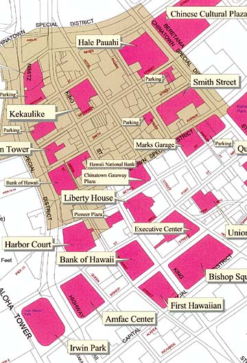
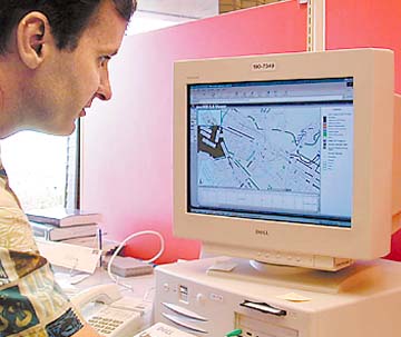
Bottom line, Schmidt and his posse of computer wranglers spend their days dumping data into computers and devising ways of sorting that data. Even better, they devise ways citizens can have easy access to this public information.We gave them a simple test. A reader asked where all the public and private parking areas were in downtown Honolulu. Schmidt's folks, within a few days, produced a full-color map of exactly what we asked for, no charge.
The city's GIS office in the Municipal Building contains plotters for producing such maps, which can be up to 54 inches wide and dozens of feet long. While we were there, they were making large maps for the attorney general's office for courtroom use.
"There are a lot of data-maintenance requirements; the trick is to make as much information as available as possible," said Schmidt. "The city has been involved in this since the mid-1980s, but the first use of geographic information systems seems to have been a cholera outbreak in London during the 1800s. Once they mapped the outbreak, and related to physical features, it became obvious the disease was coming from contaminated wells."
The real boost, however, came from Canadian forestry officials, who used dynamic mapping to chart tree-inventory and growth cycles. Other bureaucracies began to track natural resources the same way.
"Honolulu was one of the first cities in the United States to recognize the value of GIS, and we originally did it mostly for police- and fire-department planning," said Schmidt. "Before long, every department in the city was bringing us data, from environmental to wastewater. Everyone."
Prior to the massive data dump, each city department was its own little fiefdom of knowledge.
Currently, the city's GIS database contains more than 85 layers of information, from census tracts to coastal boundaries to elevation contours to political districts to streets, sewers and water mains, to land titles to zip codes to watersheds to parks to the location of each and every fire hydrant. Any department can access all of the data, all of the time.
"Which makes for better and faster service when a citizen asks for something -- you can often get information right over the telephone instead of having to come down to an office and wait," said Schmidt. "For example, for zoning and permitting questions, you can call up the existing utilities and see how it affects land use. This is a real-world benefit. This capability isn't just used for data analysis and urban modeling any more. It's not Sim City, but it almost is!"
Other municipalities use similar systems, tweaked for local customs. For example, Hong Kong has feng shui information in its GIS data. Honolulu lists archaeological sites, but not what's in them.
The mayor and the council have been supportive of the program because of the efficiencies it brings, said Schmidt. Just being able to file data on time for the Environmental Protection Agency has saved the city millions of dollars in fines, he said. "Map production alone is down $200,000 from where it was a few years ago."
In November you'll be able to fill out permit forms online, via a program called POSSE. "A whole new system will track and manage the permits, and we'll know where we're at at any particular time. There will be the ability to make decisions quickly."
Various departments access the information via the city's Intranet, using ArcView software. City government also made the policy decision to make all city data free to the public. Map reproduction is done at cost, generally just a few dollars. "We're hoping that businesses can take advantage of the data and provide products and services," said Schmidt. "If we did it ourselves, we'd be inhibiting the economic potential for private businesses. Already, the film industry and the car-rental business have used it a lot."
There's also access to a streamlined version of the city's GIS database via the Internet, about 30 layers of information. The address is http://204.182.239.30/honolulu, or you can just go to the city's homepage at www.co.honolulu.hi.us and look under Government, City Hall Online, GIS Data. The Honolulu Board of Realtors maintains a link on its site as well.
"It's unlimited in the way it ties social issues together," said Schmidt. "Geography is an excellent vehicle for showing how we interact, because our relationships are spatial in nature. Police have actually solved crimes using this system, because they can view patterns."
Everything is kept in a "data warehouse" about the size of a two-drawer file cabinet, and backed up every day. "It's only about 92 gigabytes at the moment, but we've started scanning all the old construction and architectural plans used by the city, and images require a lot of room. We're talking terrabytes. Architects are already asked to file their digital autocad files for subdivisions."
City inspectors have started using "ruggedized" briefcase computers so they no longer have to pick up assignments at a central location and fill out paper forms. The laptop transmits the data into the central GIS computer via telephone lines and the inspectors can obtain a checklist of sites to visit and in what order.
It's a means of making sure inspectors are actually inspecting.
"Efficiencies come on many levels," said Schmidt. "One level is accountability. When we're talking about tax dollars, they have to be spent as efficiently as possible."
Click for online
calendars and events.
