Advertisement - Click to support our sponsors.

Hurricane Daniel
still ‘very active’
Daniel should weaken, but
could still bring strong winds
and a lot of rainIslanders are advised to take
preparedness actions listed
in their phone booksFOR LATEST STORM UPDATES
By Helen Altonn
CHECK BREAKING NEWS
Star-BulletinHurricane Daniel held on to its hurricane title today after picking up a little strength, but it was expected to weaken to a tropical storm by tonight.
The hurricane's eye had disappeared but re-formed this morning, said Jim Weyman, director of the Central Hurricane Center at the National Weather Service in Honolulu. "The circulation appeared visible."
More southerly flow of warm, moist air in the center of the storm possibly caused the eye to flare up, he said.
"But it's still expected to continue weakening," he said. "We often see changes up and down in intensity, but we keep the same general trend."
A tropical storm watch was expected to be issued for the Big Island and Maui at about 11 a.m., "which means tropical storm-force winds are possible in the next 36 hours," Weyman said. "It will be a little later on Maui."
Get the latest storm position and track information at:
http://www.nws.noaa.gov/pr/hnl/cphc/tcpages/DANIEL.shtml
Hawaii Standard Time is minus 10 hours from NOAA's z-time or "zulu time."
A tropical storm warning is expected to be issued for Oahu and Kauai at 11 a.m. tomorrow, meaning it is bearing winds of 39 mph to 73 mph, said Oahu Civil Defense Agency Administrator Joe Reed. He warned residents of possible flooding, along with high winds accelerated by the island's mountain ridges and valleys.
Coastal areas will be subject to pretty strong high surf and surge as the storm moves up the chain, he said.
"Anyone living or driving in those areas, especially at night: Don't do it during the passage of the storm.
"There may be a tendency for some people to think, 'This is only a tropical storm,'" Reed added. "That could be dangerous."
A tropical storm, even a fairly moderate or weak one, can result in hazardous conditions, he said.
"It's still going to be a significant event if it continues to follow its current track," Weyman said, advising islanders to take preparedness actions listed in their phone books.
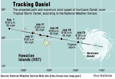
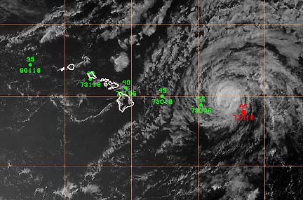
Daniel was about 630 miles east of Hilo this morning and 830 miles east of Honolulu. It was traveling at 18 mph, with 75-mph winds gusting to 90 mph.
"It's a very active system at the present time," Weyman said. The winds will begin decreasing but they will still be strong, and residents can expect a lot of rain, he said.
Weyman said three things were happening to weaken the hurricane: colder, more stable air moving in from the north, warmer ocean temperatures (78 to 79 degrees Fahrenheit), and a sheer at the upper levels.
The bottom of the storm is moving westerly while winds are pushing to the northeast in the upper part, at more than 24,000 feet, he said, explaining the sheer.
Weyman has been holding conference calls with state and county Civil Defense agencies, the Federal Emergency Management Agency, Red Cross and other emergency agencies, which are continuing to follow the storm. He briefed military officials and county Civil Defense administrators this morning.
Weyman said the storm potentially will affect the Big Island tomorrow night, Maui late tomorrow night or early Monday, Oahu Monday morning and maybe into the afternoon, then Kauai Monday afternoon into the evening.
If it continues on its present route, it is estimated to be about 30 miles east-northeast of Kahului, Maui, at 8 p.m. Sunday and 120 miles east of Honolulu.At 2 a.m. Tuesday it will be centered over Maui and about 100 miles east of Honolulu.
It will be packing winds as strong as 40 mph with gusts of 55 mph as it passes north of the Big Island and goes across Maui, Weyman said. When it reaches Oahu and Kauai, its winds will be 40 mph, with 50-mph gusts.
"With those kinds of winds, it still could blow things around," he said.
On the storm's present track, the center of its eye will pass north of the Big Island, so probably only that side will be affected, he said.
But all of Maui, Oahu and Kauai are expected to get a soaking with an estimated 6 to 8 inches of rain.
The rain probably will be spread over a 10- to 12-hour period as the storm passes through the islands, Weyman said.
A high-surf advisory was issued with 8- to 12-feet surf forecast for the Big Island and Maui, especially east-facing shores.
"Then, as the center moves through, we could have higher wind waves, depending where the storm would move," Weyman said.
Two Air Force C-130 airplanes -- hurricane hunters -- from Keesler Air Force Base in Mississippi have arrived, and two more were coming here this morning.
They were to begin flying through the storm this afternoon and continue around the clock, every six hours.
Glenn Lockwood, director of disaster services for the Red Cross in Hawaii, said its 1,500 statewide disaster volunteers have been activated and alerted that they have to travel to other islands if necessary.
Red Cross shelter team members also are prepared to staff any shelter that Civil Defense opens, and the Red Cross has supplies ready to support relief efforts, Lockwood said.
Residents should prepare a 72-hour home survival kit that includes a battery-operated flashlight, radio, spare batteries, food and bottled water, the Red Cross said.
Daniel is the second tropical storm in the Hawaii region this hurricane season, which began in June and continues through November.
Upana formed southeast of Hawaii and moved south of the islands about two weeks ago, but it was never a hurricane.
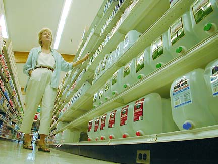
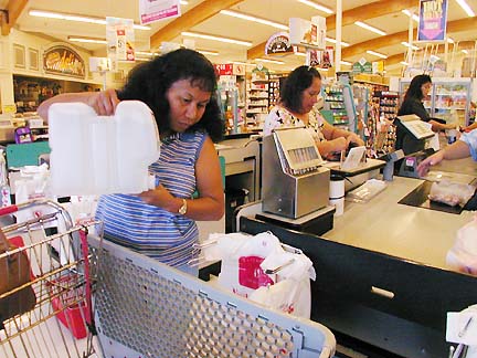
Still traumatized from Hurricane Iniki's devastation eight years ago, Kauai residents flocked to the stores and began stocking up on supplies yesterday. Bottled water had all but disappeared from store shelves around the island by noon.
Kauai police officers were told to keep the gas tanks in their patrol cars full and be prepared to be called in on short notice during off-duty periods. The Kauai Fire Department issued a similar order to its firefighters.
More information on disaster preparedness can be found on the Red Cross Web site, http://www.redcross.org.
