Advertisement - Click to support our sponsors.

ENDEAVOUR IMAGES OAHU
Improving
Oahu’s image
NASA says detail in the shuttle
By Helen Altonn
radar images will be 30 times greater
than that in existing world mapsStar-Bulletin
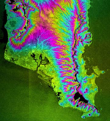
Oahu appears in spectacular detail and a rainbow of colors in a preliminary photograph from the Earth-mapping space shuttle Endeavour.
University of Hawaii scientist Peter Mouginis-Mark said only about a dozen images are being released worldwide during the mission because the data is being used "to check the health of the instrument rather than do science."
But scientists are thrilled with the first photos from the mission, scheduled to end Tuesday with a landing at the Kennedy Space Center in Florida.
The detail is so sharp that a Jet Propulsion Laboratory scientist in Pasadena, Calif., said, "I can find my house. I can find the running trails I use."
The shuttle is using an advanced measurement technique called "radar interferometry" to map the Earth's surface.
Two radar antennae form the interferometer, with one sitting on a 20-story mast sticking out from the Endeavour's cargo bay.
Mouginis-Mark, a professor in the Hawaii Institute of Geophysics and Planetology and chief scientist of the Pacific Disaster Center, said the mission "is going extremely well."
Studying the image of Oahu taken late in the day Thursday, he said, "The data quality is better than we were actually expecting, which is very good news because when the processing is finished, we will have an excellent global topographic map."
Mouginis-Mark and his colleagues will use the data to study explosive volcanoes in the Philippines, Java and the Lesser Sunda Islands east of Java.NASA said it will take about 18 months to process the images, whose detail will be more than 30 times greater than existing world maps.
"Looking at the map, which shows where they've collected data, all of the Philippines has been imaged," Mouginis-Mark said. "We will be able to do a large number of new studies on volcanoes in the Philippines."
He said there is nothing really surprising in the Oahu image, although it's a great picture. "We can easily see the Koolau Range, the Waianae Range, the coastal plain, the Ewa plain."
The radar system can see through clouds and work day and night, a big advantage "because we can get global coverage," he said.
Satellite pictures, such as those used for weather reports, always have clouds, he noted. "To produce a good topographic map, we don't want any holes."
There is one hole in the Oahu image, but it will be useful in analyzing data in other mountainous areas, he noted.
"The steep cliffs forming the Pali on the Windward side are so steep the radar couldn't measure the heights," he said.
"So the first thing I'm going to do is try and understand where the radar technique hasn't worked very well.
"An example will be going over the Pali from Honolulu to Kailua. This is the advantage of having a test data set for the area where we live: that you know the geography."
In that way, researchers can measure where the instrument worked or failed. "So where we see the same kind of problems in the Philippines or Java and can't make measurements on the ground, we've got some idea where the data is not so good," Mouginis-Mark said.
"It is a very good test of how the instrument will be able to measure mountain ranges, whether in the Andes, for example, or the Himalayas. We can show -- because we have the data now for the Pali on Oahu -- what the problems will be in other mountainous areas."
NASA had reduced mapping days on the 11-day mission from 10 to nine to allow time for an emergency space walk if the mast, which is being flown in space for the first time, becomes stuck while being retracted.
Yesterday, however, mission managers said they were looking at what they could do "to squeeze out a little more science."
Mouginis-Mark said the data will have great value locally, as well from a scientific viewpoint, because "we're looking at the Earth with the same pair of eyes."
A lot of businesses have become interested in the data, he said, "for everything from computer fly-by animations to production of new maps for hiking trails, or planning, say, different routes through the countryside."
The data also will be valuable to disaster managers, Mouginis-Mark said.
Scientists have been surprised to see clear fault lines on the preliminary images, with some speculating the images might be used to predict earthquakes.
