Advertisement - Click to support our sponsors.


Three-day forecast
Tomorrow: Breezy; clouds, sun and mainly windward showers. Wind E at 12-25 mph. 63/78
Surf forecast
Marine forecast
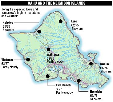
Neighbor Island forecasts
Temperatures listed are tonight's expected lows and tomorrow's highs:
Kilauea
Eruption of Kilauea continues. Lava is flowing down the side of the mountain to the sea.
Temperature
At Honolulu Airport:High yesterday -- 73
Low yesterday -- 65
Record high -- 87 (1986)
Record low -- 52 (1969)
Normal high -- 80
Normal low -- 65
Rain
Humidity -- 71%
Yesterday -- 0.29"
Month-to-date -- 0.37"
Normal month-to-date -- 2.29"
Year-to-date -- 0.37"
Normal year-to-date -- 2.29"
Sun and Moon
Sunset tonight -- 6:13 p.m.
Sunrise tomorrow -- 7:12 a.m.
Moonset tonight -- 6:46 a.m.
Moonrise tomorrow -- 7:15 p.m.Phases of the moon:
Full -- Jan 20
Last -- Jan 27
New -- Feb 5
First -- Feb 12
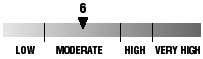
UV index
The ultraviolet index rates your risk to sun exposure. The higher the number, the greater the risk. Listed is tomorrow's forecast: 15 is the greatest risk.
The tides
Three-day forecast for Honolulu:
DAY	HIGH			LOW
Fri.	4:31a.m.	2.6 ft.	11:41a.m.	0.0 ft.
	4:37p.m.	0.8 ft.	9:58p.m.	-0.2 ft.

Sat.	5:13a.m.	2.5 ft.	-----
	5:30p.m.	0.9 ft.	12:21p.m.	0.0 ft.

Sun.	5:54a.m.	2.3 ft.	-----
	6:26p.m.	0.9 ft.	1:00p.m.	0.0 ft.
Elsewhere throughout the state tomorrow:
PLACE		HIGH	LOW	HIGH	LOW
Haleiwa		3:29	9:36	3:35	7:53
Hilo		3:27	10:42	3:33	8:59
Kailua-Kona	4:05	11:19	4:11	9:36
Kaneohe		2:45	10:23	2:51	8:40
Kawaihae	4:27	11:38	4:33	9:55
Kealakekua	4:15	11:29	4:21	9:46
Nawiliwili	4:04	11:16	4:10	9:33
Waianae		4:51	11:59	4:57	10:16
Waimanalo	3:16	10:32	3:22	8:49
THE PACIFIC
Hawaiian Volcano Observatory