

Three-day forecast
Tomorrow: Clouds and sun with a few showers in spots; windy. Wind E at 15-25 mph. 65/80
Surf forecast
Marine forecast
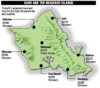
Neighbor island forecasts
Temperatures listed are tonight's expected lows and tomorrow's highs:
Kilauea
A 600-foot wide, slowly moving lava flow is creeping down Pulama Pali toward the coast but is still more than a mile from the sea.
Temperature
At Honolulu Airport:
High yesterday -- 82
Low yesterday -- 72
Record high -- 89 (1983)
Record low -- 61 (1972)
Normal high -- 83
Normal low -- 69
Rain
Humidity -- 69%
Yesterday -- 0.01"
Month-to-date -- 0.21"
Normal month-to-date -- 2.89"
Year-to-date -- 9.36"
Normal year-to-date -- 18.11"
Sun and Moon
Sunset tonight -- 5:48 p.m.
Sunrise tomorrow -- 6:52 a.m.
Moonset tonight -- 1:35 p.m.
Moonrise tomorrow -- 1:40 a.m.Phases of the moon:
New	Dec 7	First	Dec 15
Full	Dec 22	Last	Dec 29
UV index
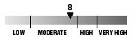
The ultraviolet index rates your risk to sun exposure. The higher the number, the greater the risk. Listed is tomorrow's forecast: "15 is the greatest risk".
Tides
Three-day forecast for Honolulu:
DAY	HIGH			LOW
Wed.	12:32a.m.	1.3 ft.	5:41a.m.	0.8 ft.
	-----			6:23p.m.	0.0 ft.

Thurs.	1:16a.m.	1.5 ft.	7:00a.m.	0.7 ft.
	12:16p.m.	1.4 ft.	6:53p.m.	0.0 ft.

Fri.	1:53a.m.	1.7 ft.	8:03a.m.	0.6 ft.
	1:01p.m.	1.2 ft.	7:20p.m.	0.0 ft.
Elsewhere throughout the state tomorrow:
PLACE		HIGH	LOW	HIGH	LOW
Haleiwa		10:24	3:36	-----	4:18
Hilo		10:22	4:42	-----	5:24
Kailua-Kona	12:06	5:19	-----	6:01
Kaneohe		9:40	4:23	11:30	5:05
Kawaihae	12:28	5:38	-----	6:20
Kealakekua	12:16	5:29	-----	6:11
Nawiliwili	12:05	5:16	-----	5:58
Waianae		12:52	5:59	-----	6:41
Waimanalo	10:11	4:32	-----	5:14
THE PACIFIC
Hawaiian Volcano Observatory