

Three-day forecast
Tomorrow: Sun, clouds; windy; windward showers spilling leeward. Wind E at 15-25 mph. 65/82
Surf forecast
Marine forecast
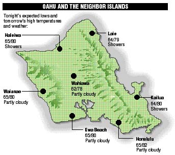
Neighbor island forecasts
Temperatures listed are tonight's expected lows and tomorrow's highs:
Kilauea
As of yesterday morning, the lava had slowed and become encrusted and only smoke was visible off the Holei pali.
Temperature
At Honolulu Airport:
High yesterday -- 85
Low yesterday -- 71
Record high -- 87 (1983)
Record low -- 57 (1990)
Normal high -- 83
Normal low -- 69
Rain
Humidity -- 77%
Yesterday -- 0.00"
Month-to-date -- 0.19"
Normal month-to-date -- 2.34"
Year-to-date -- 9.34"
Normal year-to-date -- 17.56"
Sun and Moon
Sunset tonight -- 5:48 p.m.
Sunrise tomorrow -- 6:49 a.m.
Moonset tonight -- 9:24 a.m.
Moonrise tomorrow -- 9:49 p.m.Phases of the moon:
Last	Nov 29	New	Dec 7
First	Dec 15	Full	Dec 22
UV index
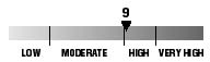
The ultraviolet index rates your risk to sun exposure. The higher the number, the greater the risk. Listed is tomorrow's forecast: "15 is the greatest risk".
Tides
Three-day forecast for Honolulu:
DAY	HIGH			LOW
Fri.	6:40a.m.	2.4 ft.	-----
	7:04p.m.	0.7 ft.	2:15p.m.	0.2 ft.

Sat.	7:34a.m.	2.3 ft.	-----
	8:36p.m.	0.7 ft.	3:20p.m.	0.2 ft.

Sun.	8:32a.m.	2.1 ft.	12:57a.m.	0.4 ft.
	10:15p.m.	0.9 ft.	4:18p.m.	0.1 ft.
Elsewhere throughout the state tomorrow:
PLACE		HIGH	LOW	HIGH	LOW
Haleiwa		5:38	-----	6:02	12:10
Hilo		5:36	-----	6:00	1:16
Kailua-Kona	6:14	-----	6:38	1:53
Kaneohe		4:54	-----	5:18	12:57
Kawaihae	6:36	-----	7:00	2:12
Kealakekua	6:24	-----	6:48	2:03
Nawiliwili	6:13	-----	6:37	1:50
Waianae		7:00	-----	7:24	2:33
Waimanalo	5:25	-----	5:49	1:06
THE PACIFIC
Hawaiian Volcano Observatory