

Three-day forecast
Tomorrow: Partly sunny; a couple windward showers. Wind E at 8-16 mph. 70/82
Surf forecast
Marine forecast
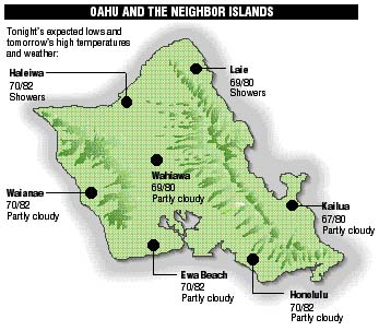
Neighbor island FORECASTS
Temperatures listed are tonight's expected lows and tomorrow's highs:
Kilauea
Kilauea has entered a quiet phase. Lava is confined to the crater and cannot be seen flowing to the sea.
Temperature
At Honolulu Airport:
High yesterday -- 83
Low yesterday -- 71
Record high -- 87 (1983)
Record low -- 62 (1976)
Normal high -- 83
Normal low -- 70
Rain
Humidity -- 75%
Yesterday -- 0.01"
Month-to-date -- 0.19"
Normal month-to-date -- 2.12"
Year-to-date -- 9.34"
Normal year-to-date -- 17.34"
Sun and Moon
Sunset tonight -- 5:49 p.m.
Sunrise tomorrow -- 6:48 a.m.
Moonset tonight -- 7:12 a.m.
Moonrise tomorrow -- 7:44 p.m.Phases of the moon:
Last	Nov 29	New	Dec 7
First	Dec 15	Full	Dec 22
UV index
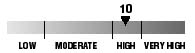
The ultraviolet index rates your risk to sun exposure. The higher the number, the greater the risk. Listed is tomorrow's forecast: "15 is the greatest risk".
Tides
Three-day forecast for Honolulu:
DAY	HIGH			LOW
Wed.	4:59a.m.	2.6 ft.	-----
	4:51p.m.	0.9 ft.	12:08p.m.	0.2 ft.

Thurs.	5:48a.m.	2.5 ft.	-----
	5:51p.m.	0.8 ft.	1:11p.m.	0.2 ft.

Fri.	6:40a.m.	2.4 ft.	-----
	7:04p.m.	0.7 ft.	2:15p.m.	0.2 ft.
Elsewhere throughout the state tomorrow:
PLACE		HIGH	LOW	HIGH	LOW
Haleiwa		3:57	10:03	3:49	8:15
Hilo		3:55	11:09	3:47	9:21
Kailua-Kona	4:33	11:46	4:25	9:58
Kaneohe		3:13	10:50	3:05	9:02
Kawaihae	4:55	-----	4:47	12:05
Kealakekua	4:43	11:56	4:35	10:08
Nawiliwili	4:32	11:43	4:24	9:55
Waianae		5:19	-----	5:11	12:26
Waimanalo	3:44	10:59	3:36	9:11
THE PACIFIC
Hawaiian Volcano Observatory