

Three-day forecast
Tomorrow: Mostly sunny, pleasant; a windward shower. Wind E at 8-16 mph. 66/84
Surf forecast
Marine forecast
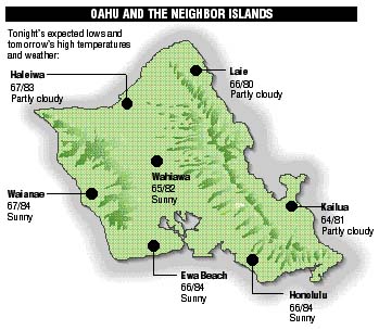
Neighbor island FORECASTS
Temperatures listed are tonight's expected lows and tomorrow's highs:
Kilauea
Lava is flowing on the surface southeast of Puu Oo crater.
Temperature
At Honolulu Airport:
High yesterday -- 83
Low yesterday -- 67
Record high -- 90 (1995)
Record low -- 61 (1964)
Normal high -- 84
Normal low -- 70
Rain
Humidity -- 62%
Yesterday -- 0.00"
Month-to-date -- 0.08"
Normal month-to-date -- 1.52"
Year-to-date -- 9.23"
Normal year-to-date -- 16.74"
Sun and Moon
Sunset tonight -- 5:49 p.m.
Sunrise tomorrow -- 6:44 a.m.
Moonset tonight -- 1:09 a.m.
Moonrise tomorrow -- 2:48 p.m.Phases of the moon:
Full	Nov 22	Last	Nov 29
New	Dec 7	First	Dec 15
UV index
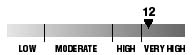
The ultraviolet index rates your risk to sun exposure. The higher the number, the greater the risk. Listed is tomorrow's forecast: "15 is the greatest risk".
Tides
Three-day forecast for Honolulu:
DAY	HIGH			LOW
Thurs.	12:50a.m.	1.3 ft.	6:10a.m.	0.7 ft.
	12:05p.m.	1.6 ft.	6:49p.m.	0.0 ft.

Fri.	1:28a.m.	1.6 ft.	7:17a.m.	0.6 ft.
	12:52p.m.	1.5 ft.	7:20p.m.	-0.1 ft.

Sat.	2:06a.m.	1.9 ft.	8:17a.m.	0.5 ft.
	1:38p.m.	1.4 ft.	7:52p.m.	-0.1 ft.
Elsewhere throughout the state tomorrow:
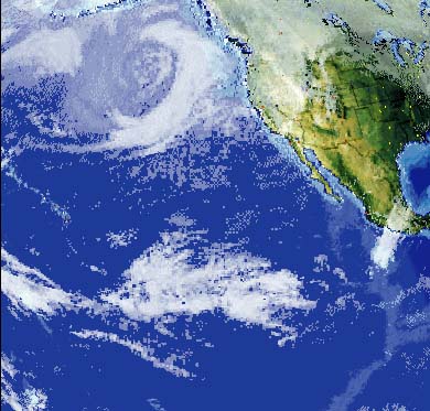
PLACE		HIGH	LOW	HIGH	LOW
Haleiwa		11:03	4:05	-----	4:44
Hilo		11:01	5:11	-----	5:50
Kailua-Kona	12:24	5:48	-----	6:27
Kaneohe		10:19	4:52	11:42	5:31
Kawaihae	12:46	6:07	12:01	6:46
Kealakekua	12:34	5:58	-----	6:37
Nawiliwili	12:23	5:45	-----	6:24
Waianae		1:10	6:28	12:25	7:07
Waimanalo	10:50	5:01	-----	5:40
THE PACIFIC
Hawaiian Volcano Observatory