

Three-day forecast
Tomorrow: Some sun; windy; windward showers spilling leeward. Wind E at 15-30 mph. 66/80
Surf forecast
Marine forecast
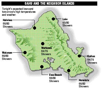
Neighbor island forecasts
Temperatures listed are tonight's expected lows and tomorrow's highs:
Kilauea
Lava activity inside Puu Oo crater remains vigorous, and lava has been seen through breaks inside a newly formed rock tube.
Temperature
At Honolulu Airport:
High yesterday -- 83
Low yesterday -- 67
Record high -- 89 (1987)
Record low -- 65 (1990)
Normal high -- 85
Normal low -- 71
Rain
Humidity -- 75%
Yesterday -- 0.00"
Month-to-date -- 0.08"
Normal month-to-date -- 0.92"
Year-to-date -- 9.23"
Normal year-to-date -- 16.14"
Sun and Moon
Sunset tonight -- 5:51 p.m.
Sunrise tomorrow -- 6:40 a.m.
Moonset tonight -- 8:52 p.m.
Moonrise tomorrow -- 10:27 a.m.Phases of the moon:
First	Nov 15	Full	Nov 22
Last	Nov 29	New	Dec 7
UV index
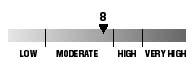
The ultraviolet index rates your risk to sun exposure. The higher the number, the greater the risk. Listed is tomorrow's forecast: "15 is the greatest risk".
Tides
Three-day forecast for Honolulu:
DAY	HIGH			LOW
Fri.	6:44a.m.	2.0 ft.	-----
	6:52p.m.	0.7 ft.	2:31p.m.	0.5 ft.

Sat.	7:32a.m.	1.9 ft.	-----
	8:18p.m.	0.7 ft.	3:36p.m.	0.4 ft.

Sun.	8:25a.m.	1.9 ft.	12:20a.m.	0.5 ft.
	10:03p.m.	0.7 ft.	4:32p.m.	0.4 ft.
Elsewhere throughout the state tomorrow:
PLACE		HIGH	LOW	HIGH	LOW
Haleiwa		5:42	-----	5:50	12:26
Hilo		5:40	-----	5:48	1:32
Kailua-Kona	6:18	-----	6:26	2:09
Kaneohe		4:58	-----	5:06	1:13
Kawaihae	6:40	-----	6:48	2:28
Kealakekua	6:28	-----	6:36	2:19
Nawiliwili	6:17	-----	6:25	2:06
Waianae		7:04	-----	7:12	2:49
Waimanalo	5:29	-----	5:37	1:22
THE PACIFIC
Hawaiian Volcano Observatory