

Three-day forecast
Tomorrow: Humid with showers and thunderstorms; heavy rainfall. Wind S at 8-16 mph. 71/82
Surf forecast
Marine forecast
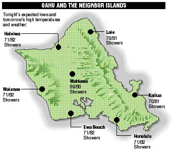
Neighbor island FORECASTS
Temperatures listed are tonight's expected lows and tomorrow's highs:
Kilauea
Eruption of Kilauea continues. Lava is flowing in a remote area of the park sluggishly to the sea.
Temperature
At Honolulu Airport:High yesterday -- 83
Low yesterday -- 66
Record high -- 91 (1996)
Record low -- 66 (1971)
Normal high -- 87
Normal low -- 72
Rain
Humidity -- 68%
Yesterday -- 0.00"
Month-to-date -- 0.06"
Normal month-to-date -- 1.17"
Year-to-date -- 7.20"
Normal year-to-date -- 14.11"
Sun and Moon
Sunset tonight -- 6:04 p.m.
Sunrise tomorrow -- 6:29 a.m.
Moonset tonight -- 1:31 a.m.
Moonrise tomorrow -- 3:31 p.m.Phases of the moon:
Full	Oct 24	Last	Oct 31
New	Nov 7	First	Nov 15
UV index
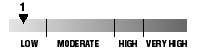
The ultraviolet index rates your risk to sun exposure. The higher the number, the greater the risk. Listed is tomorrow's forecast: "15 is the greatest risk".
Tides
Three-day forecast for Honolulu:
DAY	HIGH			LOW
Wed.	1:12a.m.	1.2 ft.	6:31a.m.	0.5 ft.
	12:58p.m.	1.9 ft.	7:42p.m.	0.2 ft.

Thurs.	1:48a.m.	1.5 ft.	7:26a.m.	0.4 ft.
	1:38p.m.	1.8 ft.	8:09p.m.	0.1 ft.

Fri.	2:24a.m.	1.7 ft.	8:18a.m.	0.4 ft.
	2:17p.m.	1.8 ft.	8:37p.m.	0.0 ft.
Elsewhere throughout the state tomorrow:
PLACE		HIGH	LOW	HIGH	LOW
Haleiwa		12:10	4:26	-----	5:37
Hilo		12:08	5:32	-----	6:43
Kailua-Kona	12:46	6:09	12:32	7:20
Kaneohe		11:12	5:13	-----	6:24
Kawaihae	1:08	6:28	12:54	7:39
Kealakekua	12:56	6:19	12:42	7:30
Nawiliwili	12:45	6:06	12:31	7:17
Waianae		3:32	8:49	3:18	10:00
Waimanalo	11:43	5:22	-----	6:33
THE PACIFIC
Volcanoes Observatory