

Three-day forecast
Tomorrow: Sun, some clouds, a few windward showers. Wind E at 10-20 mph. 69/86
Surf forecast
Marine forecast
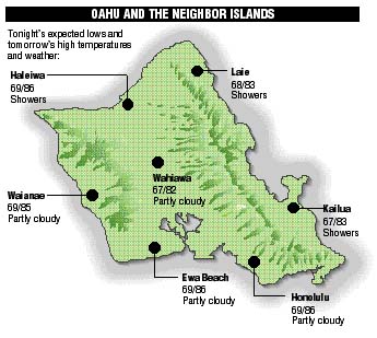
Neighbor island FORECASTS
Temperatures listed are tonight's expected lows and tomorrow's highs:
Kilauea
A broad but sluggish lava flow is moving over the steep slope of Pulama Pali but has not reached the bottom.
Temperature
At Honolulu Airport:
High yesterday -- 86
Low yesterday -- 70
Record high -- 92 (1995)
Record low -- 68 (1976)
Normal high -- 88
Normal low -- 73
Rain
Humidity -- 65%
Yesterday -- 0.00"
Month-to-date -- trace
Normal month-to-date -- 0.21"
Year-to-date -- 7.14"
Normal year-to-date -- 13.15"
Sun and Moon
Sunset tonight -- 6:16 p.m.
Sunrise tomorrow -- 6:24 a.m.
Moonset tonight -- 4:11 p.m.
Moonrise tomorrow -- 3:59 a.m.Phases of the moon:
New	Oct 9	First	Oct 17
Full	Oct 24	Last	Oct 31
UV index
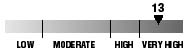
The ultraviolet index rates your risk to sun exposure. The higher the number, the greater the risk. Listed is tomorrow's forecast: "15 is the greatest risk".
The tides
Three-day forecast for Honolulu:
DAY	HIGH			LOW
Wed.	2:19a.m.	1.4 ft.	7:52a.m.	0.4 ft.
	2:16p.m.	2.0 ft.	8:51p.m.	0.2 ft.

Thurs.	2:55a.m.	1.6 ft.	8:41a.m.	0.4 ft.
	2:52p.m.	1.9 ft.	9:16p.m.	0.2 ft.

Fri.	3:29a.m.	1.7 ft.	9:26a.m.	0.4 ft.
	3:25p.m.	1.7 ft.	9:40p.m.	0.2 ft.
Elsewhere throughout the state tomorrow:
PLACE		HIGH	LOW	HIGH	LOW
Haleiwa		1:17	5:47	1:14	6:46
Hilo		1:15	6:53	1:12	7:52
Kailua-Kona	1:53	7:30	1:50	8:29
Kaneohe		12:33	6:34	12:30	7:33
Kawaihae	2:15	7:49	2:12	8:48
Kealakekua	2:03	7:40	2:00	8:39
Nawiliwili	1:52	7:27	1:49	8:26
Waianae		4:39	10:10	4:36	11:09
Waimanalo	1:04	6:43	1:01	7:42
THE PACIFIC
Volcanoes Observatory