Hokule‘a images may be
online next weekNavigators set new course
By Susan Kreifels
Star-BulletinPhotographs from the voyaging canoe Hokule'a are being transmitted and should be available on the Internet next week, but communications experts say it's more like trickling through a straw rather than gushing though a pipe.
Victoria Stevens, manager of technical support at Pacific Information Exchange Inc., which donated the telecommunications for the voyage, said kinks have been worked out and photos taken by the escort boat sailing with Hokule'a are being transmitted digitally via an Apple Powerbook G-3.
Stevens said she expects the photographs to be available midweek at http://www.hokulea.net
The images first go to the Bishop Museum, Polynesian Voyaging Society and Olelo community television.
Transmitting photos via a satellite phone is slow -- desktop modems are 22 times faster. Images and sounds, therefore, must be compressed to the smallest size possible because of the slow modem, Stevens said.
Hokule'a to Rapa Nui
Jun. 7, 1999
Rapa Nui, the Loneliest Island
Jun. 14, 1999
Equipment from the National Aeronautics and Space Administration, a voyage sponsor, would be quicker but boat motion makes it less reliable, Stevens said. "We're at the mercy of satellite phones," Stevens said. "They're fussy about cloud cover and solar flares, things land-bound people don't have to think about."
Todd Bangerter, senior Macintosh computer technician at Pacific Information Exchange (pixinet), said images were not sent for a couple of days due to overcast skies, rocking aboard the boat and some technical hurdles that have been resolved.
The Hokule'a is headed for the Marquesas Islands, the first stop on a voyage that will end in Rapa Nui, also known as Easter Island.
Navigators aboard the canoe use only the stars, waves and other signs of nature to guide the canoe rather than modern navigational equipment, replicating voyages of the ancient Polynesians who populated the vast Pacific islands.
The only contact the Hokule'a has with the rest of the world is satellite phone communication, Stevens said.
"The wonderful aspect of setting up communications for Hokule'a is recognizing two very elegant technologies, ancient navigation skills and modern computer technology, cannot only intersect but meet at a point that almost defines miraculous," Stevens said.
Guy Kaulukukui, chairman of Bishop Museum's education department, said NASA is a major contributor of the voyage through the museum's Traditional Explorers of the Pacific project. Outrigger Hotels & Resorts is underwriting the expensive satellite phone time and Olelo is providing TV air time, editing and other expertise.
The public can track the progress of the Hokule'a on the World Wide Web at http://leahi.kcc.hawaii.edu/org/pvs/
Star navigators set new
By Susan Kreifels
course after missing
Marquesas
Star-BulletinSeabirds will be their biggest clue.
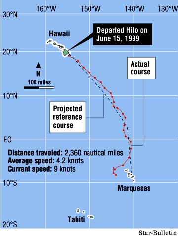
The crew of the Hokule'a is zigzagging its way northeast against prevailing winds to try to find the Marquesas Islands after missing them the first time, sailing 200 miles west of the island group.
Nainoa Thompson, who will be navigating the traditional canoe on its last leg of the historic Rapa Nui voyage, said in Honolulu yesterday that the crew will be watching for birds as a sign they are approaching the Marquesas.
The Hokule'a navigators, like the ancient Polynesian sailors, rely on the stars, waves and other signs of nature to guide them rather than modern navigational equipment. The Hokule'a has been retracing the routes of the Polynesian explorers for the past 25 years.
Thompson praised the Hokule'a crew, which had made good progress since setting sail from Hilo on June 15.
"Few people on Earth can do this," Thompson said about Hawaii's star navigators.Sailing against prevailing winds will teach the crew lessons that will be valuable for Thompson when he takes over navigation later this year. He and three other experienced navigators will guide the Hokule'a on the most difficult part of the voyage: 1,450 miles from Mangareva against prevailing winds to Rapa Nui, the most isolated inhabited island in the world. Thompson has said there's a chance the canoe could miss Rapa Nui, also known as Easter Island.
Thompson said if the canoe had sailed much farther west, he would have considered calling it via satellite communications to suggest guidance. One safety consideration is days at sea: Yesterday the crew finished their 22nd day at sea and Thompson predicted it would take three to four days to tack northeast back to the Marquesas if the same weather conditions prevailed.
The Hokule'a has enough food for 36 days, and they haven't caught many fish along the way.
The canoe yesterday was approximately 8 degrees south of the equator and 185-190 miles west of the Marquesas.
The crew has no modern-day indicators of time or place. They even store their watches. Voyage organizers in Hawaii also called off all telephone interviews with media in the past few days so as not to give the crew any clues of their location.
When Thompson called chief navigator Bruce Blankenfeld yesterday, he couldn't give Blankenfeld any clues either.
"It was hard, I could hear it in Bruce's voice," Thompson said about the crew's realization they had sailed west of their destination. "I bet he is sensing my anxiety.
"I feel like I'm on the voyage. My sleep is that way, my thought patterns. I'm consumed."