

THREE-DAY FORECAST
Tomorrow: Partly sunny and windy; windward showers. Wind E at 12-24 mph. 73/85
SURF FORECAST
MARINE FORECAST
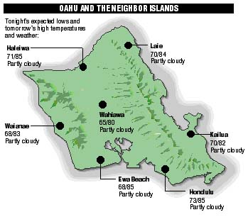
NEIGHBOR ISLAND FORECASTS
Temperatures listed are tonight's expected lows and tomorrow's highs:
KILAUEA
Kilauea's east rift eruption has been in a pause since Monday morning.
TEMPERATURE
At Honolulu Airport:High yesterday -- 83
Low yesterday -- 75
Record high -- 89 (1997)
Record low -- 65 (1971)
Normal high -- 87
Normal low -- 72
RAIN
Humidity -- 63%
Yesterday -- trace
Month-to-date -- 0.02"
Normal month-to-date -- 0.30"
Year-to-date -- 6.16"
Normal year-to-date -- 10.93"
SUN AND MOON
Sunset tonight -- 7:15 p.m.
Sunrise tomorrow -- 5:50 a.m.
Moonset tonight -- 10:25 p.m.
Moonrise tomorrow -- 10:00 a.m.Phases of the moon:
First	June 20	Full	June 28
Last	July 6	New	July 12
UV INDEX
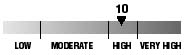
The ultraviolet index rates your risk to sun exposure. The higher the number, the greater the risk. Listed is tomorrow's forecast: "15 is the greatest risk".
THE TIDES
Three-day forecast for Honolulu:
DAY	HIGH			LOW
Thurs.	7:28a.m.	0.6 ft.	2:16a.m.	0.0 ft.
	7:32p.m.	2.0 ft.	12:08p.m.	0.1 ft.

Fri.	8:49a.m.	0.7 ft.	3:07a.m.	0.0 ft.
	8:21p.m.	1.8 ft.	1:10p.m.	0.4 ft.

Sat.	10:13a.m.	0.8 ft.	3:54a.m.	0.0 ft.
	9:11p.m.	1.6 ft.	2:31p.m.	0.6 ft.
Elsewhere throughout the state tomorrow:
PLACE		HIGH	LOW	HIGH	LOW
Haleiwa		6:26	12:11	6:30	-----
Hilo		6:24	1:17	6:28	-----
Kailua-Kona	7:02	1:54	7:06	-----
Kaneohe		5:42	12:58	5:46	-----
Kawaihae	7:24	2:13	7:28	12:05
Kealakekua	7:12	2:04	7:16	-----
Nawiliwili	7:01	1:51	7:05	-----
Waianae		9:48	4:34	9:52	2:26
Waimanalo	6:13	1:07	6:17	-----
THE PACIFIC
Volcanoes Observatory