

A look back at
Pearl Harbor
Still images once marked 'confidential' are
By Burl Burlingame
converted into a dynamic panorama offering
viewers a virtual tour of Pearl Harbor, 1944
Star-BulletinBY nature, newspapers and the photographs printed upon them are a two-dimensional medium. How much more interesting it would be if photographs were more like a window!
Apple Computer recognized this dimensional ambiguity, and its QuickTime VR software was designed to take still images in sequence and stitch them together electronically, seamlessly, creating a kind of software "movie" that can be viewed in any dimension or direction -- up, down, left, right, zoom in, zoom out. The effect is like standing in one spot and moving your head.
The process is used primarily to create virtual "tours." But it can also be used to make history come alive, if the right images are available.
This was the first thing that popped into our heads upon seeing eight recently uncovered photos that show Pearl Harbor in 1944.
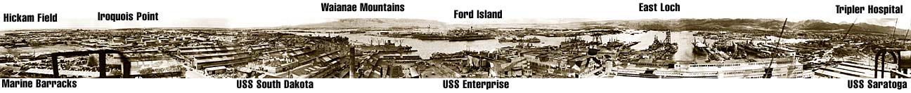
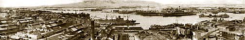
Stamped "Confidential" and from the Robert F. Walden Collection -- a treasure trove of hundreds of photographs and papers documenting the infrastructure of Pearl Harbor during the war years -- the images are taken in sequence about 100 feet above the ground and sweep about 280 degrees across the harbor in 1944.
A Liberty ship and a Portland-class cruiser that may be the USS Indianapolis
are moored in the foreground. In the background, wreckage from the Pearl
Harbor attack can still be seen in the water beside Ford Island.
The "blind spot" to the south and southeast would have shown Diamond Head and Honolulu. The center point is on Avenue D, between 7th and 8th streets in the shipyard, near the drydocks.The pictures were likely taken from a construction crane. The harbor is chockablock with warships, including the USS Saratoga, the USS Enterprise and a South Dakota-class battleship. All buildings are camouflaged to make their outlines indistinct.
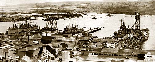
This view is looking west at the mouth of Pearl Harbor, across the drydock
area. The large dark aircraft carrier moored next to Ford Island is the
USS Enterprise. The Waianae mountain range is in the background.
Lt. Walden was a U.S. Navy engineer stationed at Pearl Harbor for the duration, working first on salvage of battleships lost in the Dec. 7, 1941, Japanese attack, and then on the construction of Civilian Housing Area III. He also managed the base motor pool and worked with civilian stevedores. His widow Nancy manages the collection.The first step in converting the still images to a dynamic panorama was to scan them into digital files, clean them up and electronically "blend" transitions from one to another. The camera's focal length changes the parallax from frame to frame, and so some buildings in the foreground seem to develop "the bends" as it move from one angle to another.
|
V R — P A N O R A M A |
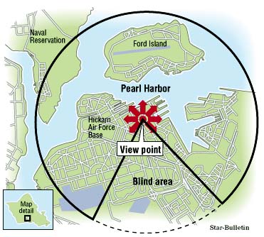
The photos cover the radius marked in the map above.
The black-and-white images were "tinted" to provide additional detail and cleaned as much as possible of surface artifacts. Star-Bulletin Jedi webmaster Blaine Fergerstrom then used QuickTime VR to meld the pictures seamlessly on the Star-Bulletin web site.The panorama is viewable on any platform that has QuickTime software, and will take several minutes to download. Place the cursor anywhere in the frame and hold down the button to scroll. Experiment with your keyboard to find the keys that zoom in and out.
How useful is this experiment?
Historian and University of Hawaii professor John Stephan, author of "Hawaii Under the Rising Sun," was impressed.
"This has real potential, absolutely!" he said. "It gives one the opportunity to explore details and spatial relationships that aren't apparent from the written word. It's so intriguing. There is much new in graphical approaches to history like this -- it's as close as we'll get to actually standing there."
He also admitted that while he was "looking around Pearl Harbor in 1944," he hummed like "a Mitsubishi fighter plane. That's how caught up I was."
Walden's Pearl Harbor panorama is viewable on today's Star-Bulletin Web site: https://archives.starbulletin.com in the Features section and, with some additional details, at http://pacifichistory.com.
MORE Quicktime VR images are linked
to our Hawaii Inc. story on the closing of
Andy's Drive-Inn in Kailua.
Click for online
calendars and events.

