

THREE-DAY FORECAST
Tomorrow: Partly to mostly sunny; breezy; windward showers. Wind E at 15-25 mph. 68/86
SURF FORECAST
MARINE FORECAST
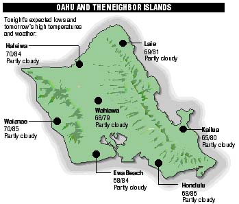
NEIGHBOR ISLAND FORECASTS
Temperatures listed are tonight's expected lows and tomorrow's highs:
KILAUEA
Occasional glimpses of a seaside lava flow can be seen by telescope from a Hawaii Volcanoes National Park viewing site.
TEMPERATURE
At Honolulu Airport:High yesterday -- 84
Low yesterday -- 74
Record high -- 89 (1996)
Record low -- 66 (1974)
Normal high -- 85
Normal low -- 71
RAIN
Humidity -- 64%
Yesterday -- trace
Month-to-date -- 2.12"
Normal month-to-date -- 0.92"
Year-to-date -- 6.12"
Normal year-to-date -- 10.42"
SUN AND MOON
Sunset tonight -- 7:07 p.m.
Sunrise tomorrow -- 5:50 a.m.
Moonset tonight -- 3:10 a.m.
Moonrise tomorrow -- 4:28 p.m.Phases of the moon:
Full	May 29	Last	June 6
New	June 13	First	June 20
UV INDEX
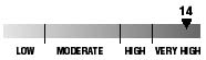
The ultraviolet index rates your risk to sun exposure. The higher the number, the greater the risk. Listed is tomorrow's forecast: "15 is the greatest risk".
THE TIDES
Three-day forecast for Honolulu:
DAY	HIGH			LOW
Wed.	1:20a.m.	1.0 ft.	7:37a.m.	-0.2 ft.
	2:37p.m.	1.6 ft.	9:03p.m.	0.3 ft.

Thurs.	1:58a.m.	0.9 ft.	8:01a.m.	-0.2 ft.
	3:07p.m.	1.8 ft.	9:47p.m.	0.3 ft.

Fri.	2:34a.m.	0.8 ft.	8:26a.m.	-0.2 ft.
	3:38p.m.	1.9 ft.	10:30p.m.	0.2 ft.
Elsewhere throughout the state tomorrow:
PLACE		HIGH	LOW	HIGH	LOW
Haleiwa		12:18	5:32	1:35	6:58
Hilo		12:16	6:38	1:33	8:04
Kailua-Kona	12:54	7:15	2:11	8:41
Kaneohe		-----	6:19	12:51	7:45
Kawaihae	1:16	7:34	2:33	9:00
Kealakekua	1:04	7:25	2:21	8:51
Nawiliwili	12:53	7:12	2:10	8:38
Waianae		3:40	9:55	4:57	11:21
Waimanalo	12:05	6:28	1:22	7:54
THE PACIFIC
Volcanoes Observatory