

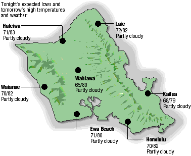
Three-day forecast
Tomorrow: Sunshine, patchy clouds and mauka showers. Wind SE at 8-15 mph. 70/82
Surf forecast
Marine forecast
Neighbor Island forecasts
Temperatures listed are tonight's expected lows and tomorrow's highs:
Kilauea
No lava is flowing on the surface, but underground flows are producing steam at the edge of the sea.
Temperature
At Honolulu Airport:High yesterday -- 80
Low yesterday -- 70
Record high -- 90 (1996)
Record low -- 63 (1987)
Normal high -- 85
Normal low -- 70
Rain
Humidity -- 84%
Yesterday -- 0.37"
Month-to-date -- 0.98"
Normal month-to-date -- 0.52"
Year-to-date -- 4.98"
Normal year-to-date -- 10.02"
Sun and Moon
Sunset tonight -- 7:02 p.m.
Sunrise tomorrow -- 5:54 a.m.
Moonset tonight -- 6:36 p.m.
Moonrise tomorrow -- 6:21 a.m.Phases of the moon:
New -- May 15
First -- May 21
Full -- May 29
Last -- June 6
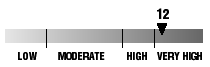
UV index
The ultraviolet index rates your risk to sun exposure. The higher the number, the greater the risk. Listed is tomorrow's forecast: "15 is the greatest risk".
The tides
Three-day forecast for Honolulu:
DAY	HIGH			LOW
Sat.	3:40a.m.	0.9 ft.	9:29a.m.	-0.4 ft.
	4:38p.m.	2.2 ft.	11:34p.m.	0.0 ft.

Sun.	4:29a.m.	0.8 ft.	10:07a.m.	-0.4 ft.
	5:26p.m.	2.3 ft.	-----


Mon.	5:23a.m.	0.6 ft.	12:36a.m.	0.0 ft.
	6:16p.m.	2.2 ft.	-----
Elsewhere throughout the state tomorrow:
PLACE		HIGH	LOW	HIGH	LOW
Haleiwa		2:38	7:24	3:36	9:29
Hilo		2:36	8:30	3:34	10:35
Kailua-Kona	3:14	9:07	4:12	11:12
Kaneohe		1:54	8:11	2:52	10:16
Kawaihae	3:36	9:26	4:34	11:31
Kealakekua	3:24	9:17	4:22	11:22
Nawiliwili	3:13	9:04	4:11	11:09
Waianae		6:00	12:52	6:58	-----
Waimanalo	2:25	8:20	3:23	10:25
THE PACIFIC
Volcanoes Observatory