
The Arctic polar icecap
By Helen Altonn
is melting; UH geologist
wants to know why
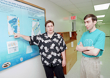
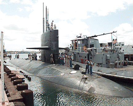
Star-BulletinUNIVERSITY of Hawaii geologist Margo Edwards will make history when she joins the nuclear submarine USS Hawkbill on a research mission in the Arctic Ocean early next month.
For one thing, as chief scientist for the expedition, the director of the Hawaii Mapping Research Group will be "breaking a time record" for a woman on the submarine.
"I'm sure it's going to be really exciting," she said. "It's a wonderful opportunity to see something nobody's seen before."
Scientists hope investigations of the sea floor under the Arctic icecap -- mapped for the first time last year -- will help them understand the planet better. They're investigating the geology and biology of the Arctic Ocean, the ridges and rises, circulation and warming of the waters and evidence of glaciation, among other projects.
"We know the Earth goes through these glacial cycles," Edwards said. "Are these changes we're seeing related to something human beings are doing? Or is this a natural part of the Earth cycle?"
The research mission is the last of five conducted annually in the Arctic under an agreement between the Navy and civilian science community.
The Hawkbill, a Sturgeon-class fast-attack submarine, left Pearl Harbor Thursdayfor the eight-week expedition. It's the last mission for the Hawkbill, being decommissioned later this year, and the last deployment for a Pacific Sturgeon-class submarine.
Eleven days under the ice
A complex sonar system called SCAMP -- Seafloor Characterization and Mapping Pods -- was mounted on the submarine's hull last year, giving scientists their first good look at the Arctic's ocean bottom.The instruments penetrate the ice pack to provide information on depth, texture and sediments. A 3-dimensional picture can be created to see what's happening with volcanism and the Earth's tectonic plates, Edwards said.
Edwards will fly to Barrow, Alaska, in a few weeks and be flown by the Arctic Submarine laboratory to an ice camp to join her colleagues.
She will make two trips in the submarine, totaling 11 days. She doesn't anticipate any problems living under the ice. A three-day trial run on the Hawkbill last month "went well," she said.
Edwards is involved with two Arctic projects -- studying glaciation at the Chukchi Cap region with Leonid Polyak of Ohio State University, and the Lomonosov and Gakkel ridges with Bernie Coakley of Tulane University.She and Polyak this week have been analyzing data collected last year at Chukchi Cap.
Polyak, who has done research on the Arctic seas for about 25 years, said he's trying to reconstruct the history of that part of the Earth with marine data.
Looking back to see ahead
There is evidence that the Arctic had the same kind of massive glaciers in the ancient past that are seen in the Antarctic, he said.Scouring on ridges indicates huge bodies of ice dragged through the water at a depth of almost half a mile, which is "very unusual, sensational," Polyak said. The bottom of modern day icebergs may be only 150 to 180 feet deep, he said.
For the first time, Edwards said, the scientists are able to do a back-and-forth survey -- called "mowing the lawn" -- to get the depth of the iceberg scours on the ridges.
Gakkel Ridge is of major scientific interest because it's the slowest spreading mid-ocean ridge in the world.
Mid-ocean ridges basically are a combination of volcanic eruptions and tectonic plate movement, she pointed out. Some people predicted there wasn't any volcanism at Gakkel Ridge because it's spreading so slowly, but early data shows some volcanism, she said.
"It turns out that these ridges are really influencing what goes on in the water," she said. "We've discovered that these ridges are where boundaries tend to occur between (cooler) Atlantic waters and (warmer) Pacific waters."
Surprised researchers in the past decade have found the boundary moving down, with more warmer water flowing into the basin, she said.
"Obviously, the more warm water you get from the Atlantic ... the more likely to melt the polar icecap," Edwards said. "We know over the past decade the polar icecap has been shrinking. Is this something the Earth is doing or are people in cars contributing to this?"
Because sea operations are so difficult, Edwards said the National Science Foundation has given her, Polyak and Coakley proprietary rights to their data for two years. The UH mapping group will process all the other data and release it on a Web site.
"My not-so-secret agenda is to convince them (the Navy) they need more data and more trips to the Arctic to do this," Edwards said. "It's a neat program. It's good for the Navy. It's good for the scientists. And it's good for people who don't want the polar icecap to melt."
