valley trail:
koloa
steve brown has been a hike coordinator with the Hawaiian Trail and Mountain Club for nearly 20 years. A Midwest native, he came to Hawaii with the Navy in 1968. Brown, 49, is the raw-materials manager for Maui Divers, and enjoys leading group hikes for the shared sense of achievement. "It's just a great fellowship experience," he said.Like a satisfying mixed-plate lunch, the Koloa Gulch trail in Laie offers the hiker a variety of terrain. "It's actually a bit of a mix," said Brown, who chose it as his favorite valley trail. "The first part of it is on a ridge, so you get a view, and then it drops down into just a beautiful valley - lush green, a lot of ginger."
Penetrating the Windward Koolau range, the intermediate-level hike starts on a road overgrown with grass before climbing through ironwood groves to the ridge, where Laie Point, the coastline and ocean can be seen below, Brown said. The trail, sometimes obscure, then drops down to Koloa Stream for the first of more than 20 crossings along its length. Strawberry guava and mountain apple trees provide "a real treat" in the late summer and fall, when their fruit ripen.
The stream splits near the back of the gulch. Brown bears right, but both forks lead to a refreshing payoff: small waterfalls and pools where tired hikers can take a dip and eat their lunches. "You can swim out to the middle of the pool and stand on this rock that's underwater, but you better know it's there before you jump in," he said. Allow at least six hours for the round trip.
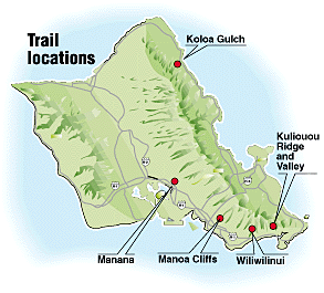
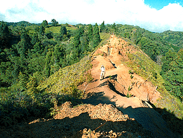
By Dean Sensui Star-Bulletin
Steep-sided walls and deep pools characterize upper
Koloa Gulch, above. Prawns are found in pools along the trail.
Some cautions: A memorial at the trailhead to a Boy Scout who died in 1994 is a sobering reminder of flash floods. For traction on slippery rocks, felt-bottomed tabi are suggested. Leptospirosis is a threat, and mosquitoes can pester. But Brown goes about once a year. "I've never seen a whole lot of people up there," he said. "It's just a beautiful area."length: 8 miles RT. trailhead: Off Kamehameha Highway about 0.7 miles past the Hau'ula Kai Shopping Center. Permit needed. Call 293-9201.
ridge walk:
kuli'ou'ou
curt cottrell, 37, heads Na Ala Hele, the state's trail program. The hiking gods have been kind to Cottrell, who came here from California in 1983 to hike Mauna Loa and the Na Pali Coast, and ended up working at a Maui estate and the Legislature. Being able to "use a chain saw on Saturday and write legislation on Monday" got him into the program as the Oahu trail specialist. "It all fit together real nicely," he marvels, "but I had no idea the pattern was emerging as I was plundering through it."
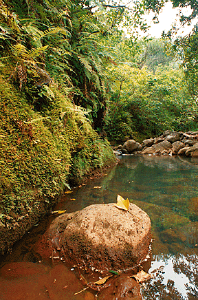
By George F. Lee Star-Bulletin
Right, climbing the stairs to the Kuli'ou'ou Ridge summit
are, from left, Paula Scatoloni, and Daniel,
Jason, Juan and Robyn Pistor.
Ending 2,000 feet up on the Koolau range, with a sweeping view that is quintessential Hawaii, the Kuli'ou'ou Ridge Trail was chosen by Cottrell as his favorite Oahu ridge hike. Less experienced hikers can do the first part, following a 10 to 12 percent gradient to a picnic shelter where they can "listen to the wind blow through the ironwood trees and stuff." Stronger hikers can continue along a steeper section to the top. "If people come to visit and they call me up, I always pick Kuli'ou'ou," Cottrell said.The hike begins at the back of an East Honolulu subdivision, past a gate where a narrow paved road forks left to a valley trail, and right to the ridge. The trail gradually switchbacks up - opening to a vista of the valley and the ocean - and continues to the ridge through ironwood trees, which can lay a soft carpet of needles underfoot. The shelter is at about the halfway point. Beyond that the going gets harder and the trail less distinct as the forest transitions to mature Norfolk Island pines. The final approach goes through a "beat-up" native forest and up about 100 steps, put there partly so people wouldn't grab and kill ferns.
At the top is a flat area made for eating lunch on a sunny day. The view has been described as world-class, taking in Waimanalo, Kailua, Makapuu, the peaks of Olomana, Koko Head, the majestic Koolau range itself and, on clear days, Molokai and Lanai. Cottrell advises against going further, and most don't. The trail can be hot, and on weekends, crowded. "I put in a lot of love time on that trail," he said. "It is truly one of my favorites."
length: 5 miles RT.
trailhead: At the end of Kala'au Place in Kuli'ou'ou Valley.
native-plant viewing:
manoa
clyde imada graduated from the University of Hawaii with degrees in horticultural technology and geography, but his passion is plants. He is a research assistant in Bishop Museum's Botany Department, and has led hikes for the museum. Imada, 41, started hiking as part of a McKinley High School program and has been at it since. While efforts are being made to protect native flora, "it's a neverending battle," he sighs.Only minutes from the concrete bustle of downtown Honolulu, the Manoa Cliffs Trail was chosen by Imada as his favorite on Oahu to see native plants. Accessibility and ease of viewing tipped the scales. "That's where I take visiting botanists who have never been to Hawaii to see a sampling of native forest," he said.
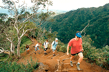
By Kathryn Bender, Star-Bulletin
The Manoa Cliffs Trail offers spectacular views of
the valley and an amazing variety of plants,
from bamboo to coffee.
Not to mention spectacular views. The well-maintained trail switches back on the east side of Tantalus, and offers wide vistas of Manoa Valley and beyond. It was once listed as a loop trail, but the state since has renamed the other half. Imada likes to connect with the Pauoa Flats Trail, which goes through a bamboo grove to a stunning overlook of Nuuanu Valley.The hike to the overlook begins with an brief uphill walk through planted forest before entering a section of koa trees, Imada said. From there, native plants abound: 'ie'ie, a tree-climbing plant sacred to the forest god Ku; kopiko, an endemic coffee species; ohia and native hibiscus, which Imada saw blooming two weeks ago. "There's all kinds of stuff on that trail," he said. "I don't know where to start."
Many species are identified by signs. To enhance the hike, which can be muddy, Imada recommends getting a $4 Manoa Cliffs plant guide from the Hawaii Nature Center in Makiki before setting out. The center, open seven days a week, also has a free map showing the area's extensive trail system. Expect to meet other hikers, but mountain bikes are prohibited. "These areas aren't pristine or anything," Imada said. "But the native stuff is holding their own up there."
length: About 41/4 miles RT.
trailhead: Just past 4005 Round Top Drive while driving up.
best challenge:
manana
stuart ball jr. is the author of a book widely regarded as the best hiking guide to Oahu. Since coming to Hawaii in 1974 from Washington, D.C., he has twice been president of the Hawaiian Trail and Mountain Club. He started hiking while at Dartmouth College, joining an outing club that went into the White Mountains. Now a Bank of Hawaii analyst, Ball, 49, continues to lead hikes "because basically I have a desk job here sitting in front of a computer."Long, ungraded, narrow and steep at parts, but easily accessible to the public - those qualities make the Manana Trail on the Leeward Koolau range Ball's choice for his favorite challenging hike on Oahu. It ends with an exhilarating stretch of open-ridge walking and views all around. "The wild, windy finish is absolutely wonderful," he wrote. "You feel like you are on top of the world."
By Dean Sensui, Star-Bulletin
The summit of the Manana Ridge Trail is recommended
for experienced hikers only, above. It offers a 360-degree
view and a thrilling walk on an open ridge.
Starting at the back of Pacific Palisades, the trail starts a 1,700-foot elevation gain on a paved Board of Water Supply road that goes past a water tank before entering a eucalyptus forest. Following the ridge and bearing left, it enters an area of rolling hills where native plants like koa and naupaka are making a comeback after a forest fire in the 1970s. The trail dips and climbs until reaching a flat hump dubbed the "helipad" about two-thirds of the way in. Intermediate hikers might want to stop there and admire the 360-degree view, which includes Pearl Harbor and the Wahiawa plain.Ball recommends only expert hikers go further. The trail becomes rougher, narrower and muddier. Cables hang at especially steep sections. "It's not like it's real scary or it's real narrow," he said. "They're just there for some assistance." Native plants and birds, like the 'apanepane, might be seen along the way. A Windward coast panorama appears at the 2,660-foot summit: Kaneohe Bay, Mokapu Peninsula, Makapuu.
The hike takes all day, and long pants are advised. Ball said mountain bikers might be encountered on the first section, but after that, distance and difficulty keep numbers down. "I've been up there and had it to myself," he said. "It's real spectacular."
length: 12 miles RT. trailhead: At the end of Komo Mai Drive in Pacific Palisades, near Pearl City.
family outing:
wiliwilinui
reese liggett, the Oahu outings chairman for the Sierra Club's Hawaii chapter, started hiking in college when he got a summer job at a New Hampshire camp. He climbed the White Mountains and peeked out above the clouds. "It was fantastic," he says. "Never forget it." Hooked, he returned the next summer as hiking counselor. The 55-year-old Liggett came to Hawaii with the Air Force in 1986 and now is an industrial real estate broker for Chaney Brooks.
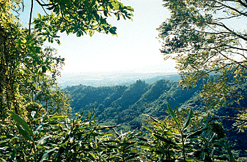
By Kathryn Bender, Star-Bulletin
Hiking the Wiliwilinui Trail are Julie Torres
and Loren Shim.
The Wiliwilinui Trail, Liggett said, is the easiest way to the Koolau summit, and his favorite family hike on Oahu. From the top are beautiful views of Koko Head, Pearl Harbor and the Windward side of the island, "and if the wind's blowing right, you can smell the dairy barns down in Waimanalo, which is something you can talk to the kids about," he laughed. "Mooooo!"The trail was closed for years while the East Honolulu hillside was developed, and reopened in mid-1995. Liggett said it goes past a water tank and along an old jeep road before gradually climbing through eucalyptus, guava and other introduced trees. Koa and other native plants later appear, until the summit is "85 percent native" - not including, of course, the radio transmitter there. He said the last quarter mile can be narrow and steep in parts, but his 7-year-old nephew completed the trail with no problems.
The Sierra Club has been part of a dispute about access through the pricey Waialae Iki V subdivision, and over parking near the trailhead. Liggett said daytime hikers do not need to show any identification at a guard shack, where they will be given a map to the trailhead. The club, in fact, chose this one for its Trails Day hike.
length: Estimated 5 miles RT. trailhead: Up Laukahi Street to a Board of Water Supply road at the end of Oko'a Street.
More Stuff
Staying safe in the great outdoors